Good morning everyone!
Skies are mostly clear early on this Thursday morning and it is incredibly warm with temperatures ranging from 82 in Clifton down to 71 at Hackettstown. Winds are calm or light southwesterly. The air quality is moderate with an index of 68.
CLIFTON’S CLIMATE DATA FOR JULY 2.
AVERAGE HIGH: 84 AVERAGE LOW: 64
RECORD HIGH: 99 – 2018 RECORD LOW: 51 – 2001
YESTERDAY: HIGH: 99 (New Record) LOW 74 PRECIPITATION: NONE
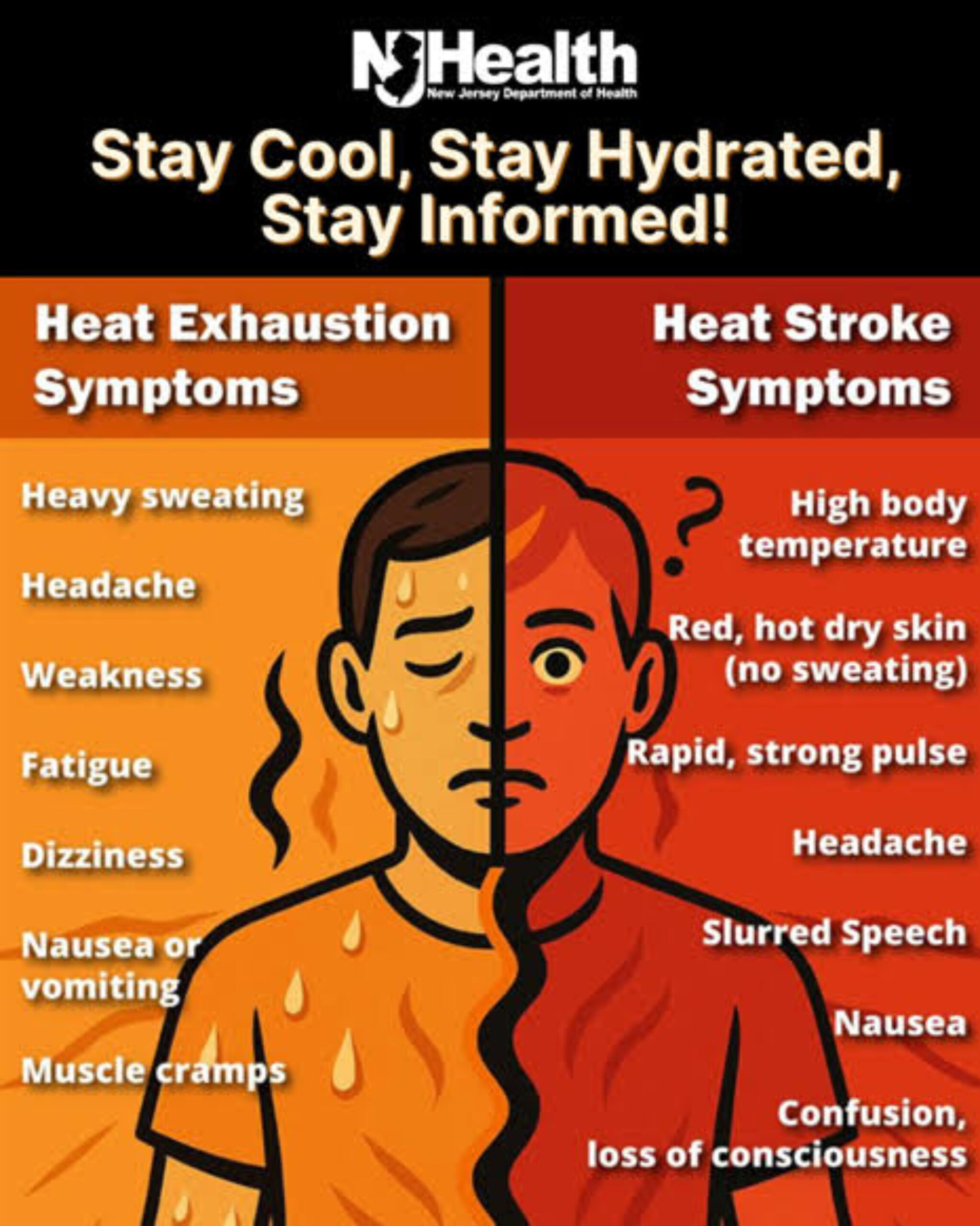
The strong ridge of high pressure will continue to give us extreme heat both today and again on Friday. High temperatures both days will rise to the low 100s. Winds from more of a westerly direction may cause dew points to fall below 70 both afternoons but heat indexes will still rise to near 110 and an extreme heat warning remains in effect. We should be mainly dry but there is a slight chance of showers and thunderstorms Friday afternoon and evening.
The extreme heat should continue on Saturday but high temperatures may be a couple of degrees lower than today and Friday as we will have more clouds and a better chance of showers and thunderstorms in the afternoon and evening, some of the storms may be strong to severe.
Less hot on Sunday with still a good chance of afternoon and evening showers and thunderstorms as a front moves into our area.
More seasonable temperatures early next week but showers and thunderstorms are likely on Monday that may extend into Tuesday morning as the front moves further to our south and high pressure builds from the north.
THE FORECAST:
TODAY – JULY 2 – Sunny and extremely hot with highs near 102, heat index to 110.
TONIGHT – Clear and warm, lows in the low 80s.
FRIDAY – JULY 3 – Sunny, breezy and extremely hot with highs near 102, heat index to 108.
INDEPENDENCE DAY – JULY 4 – Mostly sunny, breezy and very hot with a chance of afternoon and evening showers and thunderstorms, highs in the upper 90s.
SUNDAY – JULY 5 – Partly sunny with a good chance of afternoon and evening showers and thunderstorms, not as hot, highs near 90.
MONDAY – JULY 6 – Mostly cloudy with showers likely and possible some thunderstorms, highs near 80.
TUESDAY – JULY 7 – Chance of a morning shower then becoming partly sunny, highs in the low 80s.
WEDNESDAY – JULY 8 – Mostly sunny, highs in the low 80s.
MARINE FORECAST: TODAY – Southerly winds to 10 knots, seas 2-3 feet. Belmar’s ocean temperature is 71 degrees.
OUTLOOK: No advisories expected Friday through Monday.
CLIFTON’S CLIMATE SUMMARY FOR JUNE 2026. RECORDS BEGAN IN 1973.
June’s average temperature was 73.7 degrees which was 3.7 degrees above normal and was tied for the 5th warmest June on record. The highest temperature was 95 degrees set on the 11th. The lowest temperature was 49 recorded on the 2nd. Precipitation again was below normal with 2.87″ accumulating which made it tied for the 13th driest June on record.
Have a nice day but stay safe, cool and hydrated!